
Paris drops Mercator projection: France now looks smaller on world maps
On a Friday that saw two of the world's most powerful cartographic decisions land within hours of each other, Paris and New York simultaneously walked away

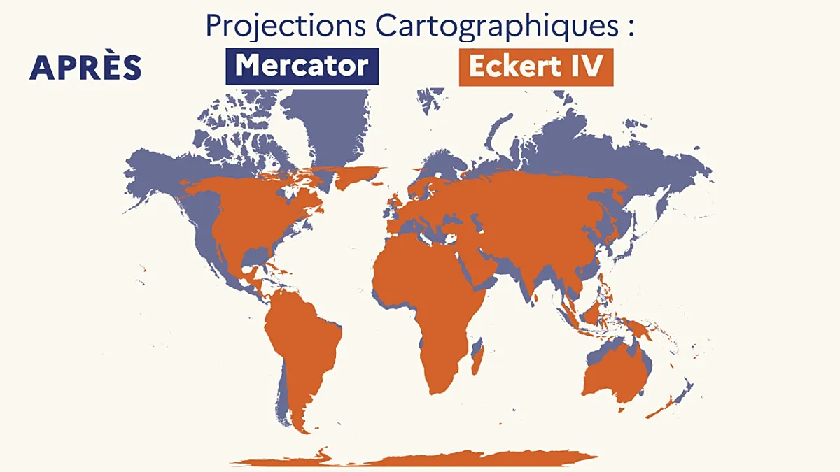
Table of Contents
France Swaps Its Diplomatic World Map, Shrinking Its Own Visual Footprint
Poinews.com – On a Friday that saw two of the world’s most powerful cartographic decisions land within hours of each other, Paris and New York simultaneously walked away from the map projection that has dominated Western classrooms and government offices for over four centuries. In the French capital, Foreign Minister Jean-Noël Barrot declared that his ministry will retire the Mercator projection from all official diplomatic cartography. In New York, just hours later, the United Nations General Assembly voted to replace the same projection with one grounded in the Equal Earth model. The coincidence of timing underscores how quickly a quiet technical choice about map geometry has become a matter of geopolitical identity.
What Mercator Gets Wrong
The Mercator projection, devised in the early 1500s to aid maritime navigation, preserves angles and directions faithfully but distorts area dramatically. The farther a landmass sits from the equator, the more it balloons on the page. Greenland, which in reality covers roughly the same surface area as the Democratic Republic of Congo or Algeria, renders on a Mercator chart as though it rivals the entire African continent. Equatorial nations, by contrast, appear compressed and diminished. For diplomats, educators, and policymakers who have relied on this projection for centuries, the visual hierarchy it encodes has quietly shaped assumptions about which regions matter and which do not.
Barrot’s Case for Change
Speaking at the Sorbonne during a public gathering titled “La Fabrique de la diplomatie,” Barrot framed the switch not as a technicality but as a correction of inherited perception. He argued that maps passed down from sixteenth-century Western navigators carry assumptions that no longer serve a fair global dialogue.
“A map is never entirely neutral. Take the Mercator projection, the one every one of us has known since childhood. The areas we see on it do not correspond to actual areas: (…) The United States, Russia, China take on a disproportionate visual importance compared with Africa, Latin America or South-East Asia.”
The minister went on to note that Greenland, despite being comparable in size to a single large African state, “seems almost as vast” as the whole continent when plotted on Mercator. His conclusion was pointed:
“Changing the map obviously does not change the world. But correcting a representation that distorts it is already an act of truth.”
Under the new arrangement, France will employ the Eckert IV projection, a design first published in 1906. Like the Equal Earth model endorsed by the UN, Eckert IV preserves the true relative sizes of continents far more faithfully than Mercator. The two projections are closely related but not identical; they differ subtly in the shapes they assign to individual landmasses. For France, the choice signals alignment with the broader reform movement while retaining a distinct national cartographic signature.
The Parallel UN Vote
The New York resolution, titled “Correcting the map” and sponsored by Togo, received the backing of 164 member states. It formally steers UN cartography toward the Equal Earth projection, a model developed in 2018 that maintains accurate area ratios across all latitudes. The African Union had already embraced Equal Earth in March of the same year, and the resolution now urges every member state to follow suit.
The vote was not unanimous. The United States cast the sole negative ballot, characterizing the measure as a “radical ideological project.” American objections centered on a passage in the resolution text stating that “correcting cartographic distortions relating to the size of continents constitutes an act of cognitive justice and memorial reparation.” Six nations—Estonia, Georgia, Lithuania, Moldova, Serbia, and Ukraine—abstained.
UN officials were careful to clarify the resolution’s limits: it does not prohibit the Mercator projection, nor does it impose a single mandatory map. Instead, it “encourages governments, educational institutions, international organisations and technology companies” to adopt Equal Earth or other equal-area projections that preserve genuine surface-area proportions.
What Changes in Practice—and What Does Not
The diplomatic switch in Paris is symbolic in the short term but carries real weight over time. Official briefings, briefing-room wall maps, and the visual language of French foreign policy will now present a world in which France occupies a proportionally modest position relative to equatorial powers. That reframing, however small, alters the subconscious geography that shapes negotiation posture and public perception.
In classrooms, the transition will be slower. Most French school atlases still default to Mercator. Grégory, a senior history-and-geography teacher in Rennes, noted that while some textbooks include the Eckert or Peters projections, their presence remains “very rare.” Whether the foreign ministry’s decision will cascade into curriculum reform is an open question, though the political signal is unmistakable.
Digital platforms present another layer of inertia. Major mapping services continue to render interactive street-level views using a variant of the Mercator projection, because its conformal properties—preserving local angles—remain indispensable for navigation and route-finding. The projection will therefore persist in everyday digital use even as it recedes from the halls of diplomacy and international governance.
Why the Geometry Matters
Cartographic projections are never purely mathematical. Every choice of projection encodes a hierarchy: what is enlarged, what is compressed, what sits at the center of the page. For over four hundred years, the Mercator projection placed northern Europe and North America at the visual apex of the world, a framing that reinforced colonial-era assumptions about centrality and periphery. Equal-area projections invert that hierarchy, giving equatorial and southern landmasses their true visual weight.
France’s adoption of Eckert IV, arriving in the same week as the UN’s Equal Earth endorsement, marks a concrete step in a broader reckoning. The maps on French diplomatic walls will look different within months. The continents will sit in their proper proportions. And the question of who, visually, “matters” on the page will finally be answered by geometry rather than by the accident of a sixteenth-century navigator’s need to plot a course.
Related Reading
Frequently Asked Questions
What is Paris drops Mercator projection?
Paris drops Mercator projection is the main topic of this guide. The article explains the context, practical details, and next steps readers should understand.
Why does Paris drops Mercator projection matter?
Paris drops Mercator projection matters because readers are looking for a useful answer, not just a short summary. Good content should match search intent and help them decide what to do next.